Disclaimer: The following is an academic exercise and the information below was obtained through open-source, unclassified platforms and research.
Excuse any overlooked formatting issues; this was brought over from my original Microsoft Word document. This is a more concise TSA format.
| Field | Entry |
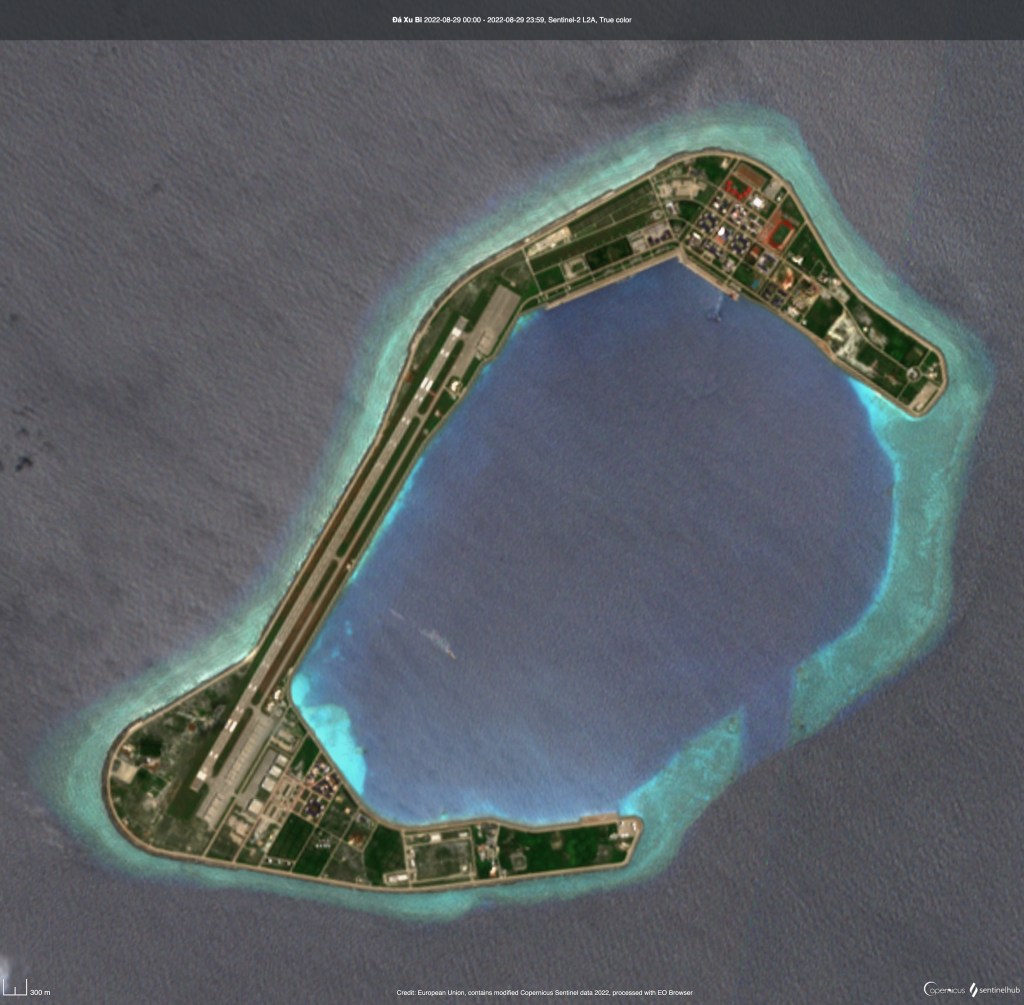
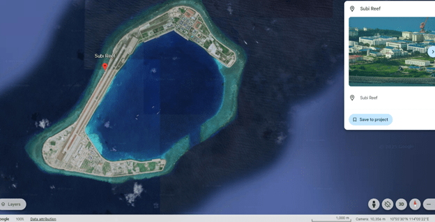
| Target Name | Subi Reef Airfield |
| Target Type | Expeditionary Airbase/Forward Air Operations Hub |
| Country | People’s Republic of China (PRC) |
| General Location | Subi Reef, Spratly Islands, South China Sea |
| Coordinates | 10.9236 N, 114.0340 E (runway midpoint reference) |
| System of Interest | Integrated airfield system enabling aircraft launch, recovery, sustainment, and local C2 |
| Data Sources | Commercial satellite imagery, open-source reporting |
| Operational Role | Supports air operations, ISR, logistics, and regional presence in the South China Sea |
| Primary Functions | Sortie generation, aircraft sustainment, fuel and logistics support, airspace control |
| Characteristics | Single long runway, centralized fuel and support infrastructure, maritime resupply dependency |
| Intended use | Unclassified training ETF; academic support to targeting product |
| Summary Assessment | Subi Reef Airfield functions as a forward-deployed air operations node with limited redundancy, reliant on a single runway, centralized sustainment systems, and maritime logistics for continued operations |
Executive Overview
Subi Reef Airfield functions as an expeditionary air operations hub supporting PRC aircraft generation, sustainment, and local C2 for maritime and air activities. Key vulnerabilities are the single runway configuration, centralized fuel storage and distribution, and primary C2/ATC nodes. Short-term effects from degrading these nodes would reduce sortie generation and situational awareness; long-term logistics interdiction could degrade sustained operations. Primary Priority Intelligence Requirements (PIRs) focus on resident aircraft types and numbers, fuel and munitions capacities and locations, and C2/resilience measures.
System of Interest (SoI)
System Purpose
Enable launch, recovery, maintenance, sustainment, and command of air operations from Subi reef. The SoI includes the airfield surface (runway, taxiways, apron), aircraft support (maintenance, fuel, munitions), C2/ATC, logistics (pier, resupply nodes), utilities (power, desalination), and force protection (air defense, perimeter sensors).
Functional Breakdown/Subsystems
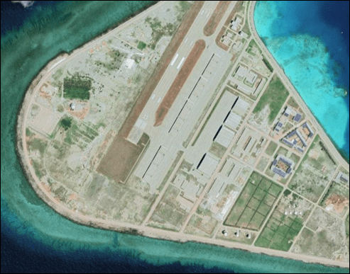
- Flight Operations: Runway, taxiways, aprons, aircraft hardstands, visual/precision approach aids, and emergency response. The single long runway appears to be the main sortie generation surface.
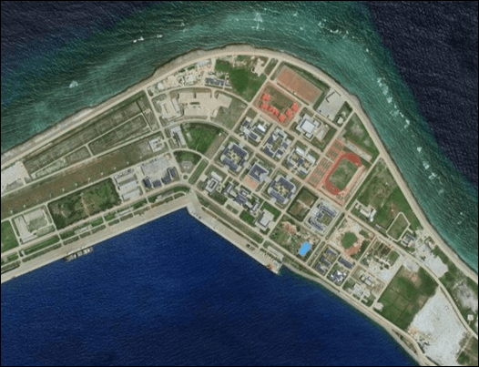
- C2/Air Traffic: Control tower or ATC shelter, local radar or approach aids, datalinks, and satellite terminals that coordinate launches and airspace deconfliction.
- Sustainment and Logistics: Fuel farm/tankage, refuel trucks, maintenance hangars, munitions storage (likely to be dispersed if present), and seaport for resupply.
- Power and Base Support: Generator clusters, fuel for generators, water/desalination systems, billeting, and administrative compounds.
- Force Protection and Sensors: Point and area air defenses, short-range AD systems, perimeter observation posts, and camouflage or hardening measures.
Critical Nodes and Single Points of Failure
- Runway strip: Single point for sortie generation; damage or contamination halts fixed-wing operations until repaired. Runway damage immediately reduces sortie generation; light surface damage is typically repairable in hours to days, while heavy crater or structural damage will require specialized engineering solutions and could take days to weeks to restore.
- Primary fuel storage/distribution: Limits sortie endurance and sortie turnaround capacity. Disruption of primary fuel storage or distribution channels would have an immediate impact on sortie endurance and turnaround rates and would degrade power generation as generators draw from the same supply.
- Primary C2/ATC node(s): Loss reduces safe launch or recovery and degrades operational tempo. Degradation of C2 and ATC nodes would sharply reduce safe flight operations, increase sortie spacing, and hinder coordinated ISR or strike integration.
- Supply pier/logistics offload point: Interdiction disrupts sustainment and heavy equipment supply. Interdiction of logistics flows to the pier or offload points would produce cumulative effects over weeks as munitions, spare parts, and fuel stocks decline.
- Power generation: Power loss affects communications, refueling systems, and lighting.
Priority Intelligence Requirements (PIRs)
The following PIRs identify the highest value questions necessary to understand Subi Reef Airfield’s operational posture and to inform collection and planning:
- What aircraft types and numbers are resident, transient, or routinely operating from the airfield?
- Where are the primary fuel and munitions storage locations and what are their capacities and hardening levels?
- What are the locations and redundancies of primary C2, ATC, and communications nodes?
- What logistics routes, both air and maritime, sustain the island and at what cadence and tonnage?
- What force protection systems, including radars and surface-to-air systems, are deployed in and around the reef along with their approximate engagement footprints?
These PIRs should be prioritized for collection tasking to close critical intelligence gaps and to refine estimates of repair timelines and sustainment vulnerabilities.
Collection Priorities and Methods
- IMINT (commercial satellite): Frequent tasking to track aircraft presence, construction and hardening, fuel truck movement, pier activity, and new defensive emplacements.
- SIGINT: Monitor airfield communications, ATC chatter, datalink emissions, and radar signatures to identify C2 nodes and defensive system activation.
- Maritime monitoring (AIS, SAR): Track resupply patterns and logistics ships servicing the reef.
- OSINT: Contractor or engineering reporting, procurement anomalies, and open imagery.
- HUMINT: Ground exploitation and assessment teams for on-site verification and munitions or fuel capacity confirmation post-event.
Battle Damage Assessment Metric and Indicators
BDA for Subi Reef Airfield will focus on observable indicators that reveal changes in operational capacity and recovery activity. Key measures include variations in sortie rates and visible aircraft counts on aprons, as these will reflect the airfield’s ability to generate and sustain flight operations. Imagery revealing runway repairs, temporary matting, or resurfacing indicates the tempo and efficiency of engineering recovery. Monitoring the frequency of fuel truck activity, visible fuel levels in storage tanks, and the return of ATC transmission or radar emissions provides insight into logistics and command restoration. Lastly, the arrival of logistics ships, the scale of offload operations at the pier, and renewed construction activity will serve as strong indicators of the airfield’s recovery status and resilience over time.
Recovery Estimates (High Level)
- Runway light damage – hours to repair using local crews and materials.
- Runway crater or heavy structural damage – days to weeks depending on matting/module availability and engineering support.
- Fuel node replacement or resupply – days to weeks depending on logistics access.
- C2 restoration via alternate datalinks – hours to days if redundant terminals exist; longer if critical hardware is destroyed.
Legal and Strategic Considerations
All analysis and any recommended engagements need to comply with the Law of Armed Conflict (LOAC), applicable Rules of Engagement (ROE), and Joint Force Commander (JFC) guidance. Special consideration needs to be given to dual-use infrastructure and collateral risk to maritime traffic and neutral parties in the South China Sea.
Analytic Confidence
Moderate confidence: imagery and open-source data provide clear external layout and construction indicators; internal capacities like fuel tank volumes, munitions types, and specific aircraft counts remain estimates without corroborating SIGINT and/or HUMINT.

Leave a comment