Disclaimer: The following is an academic exercise and the information below was obtained through open-source, unclassified platforms and research.
Excuse any overlooked formatting issues; this was brought over from my original Microsoft Word document. This is a more robust TSA format.
Target Identification
| Field | Entry |
| Target Name | Longpo Naval Base (Greater Yulin) |
| Target Type | Naval Base, Submarine and Surface Fleet Operating Complex |
| Country | People’s Republic of China (PRC) |
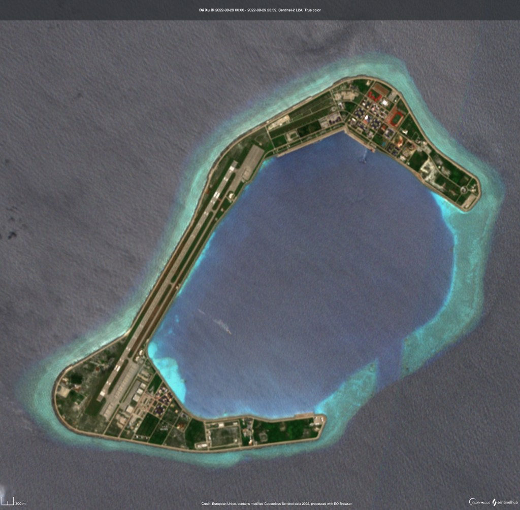
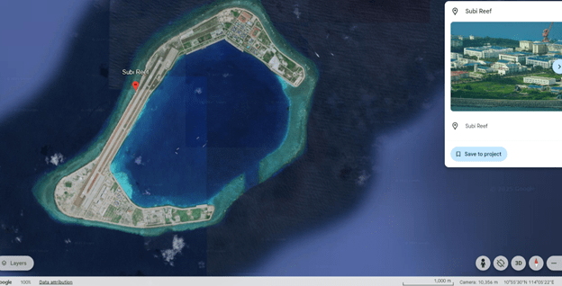
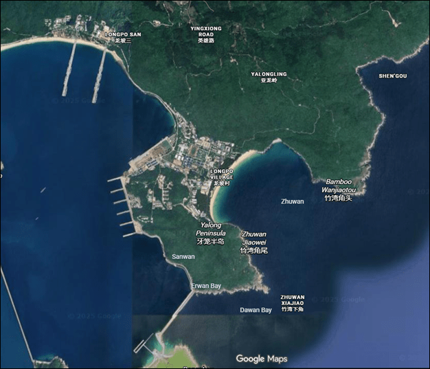
| General Location | Yalong Peninsula, near Sanya, Hainan Island |
| Coordinates | 18.207278, 109.69472 (central base reference) |
| Data Sources | Commercial satellite imagery, open-source reporting |
| Intended Use | Unclassified training ETF; academic support to targeting product |
| Summary Assessment | High-readiness, permanently manned naval operating complex supporting submarine and surface vessel sustainment, with indicators of hardened subsurface infrastructure and localized air defense. |
Executive Overview
Longpo Naval Base is assessed as a high-readiness, permanently manned, multi-mission naval installation supporting both submarine and surface fleet operations for the PLA Navy (PLAN) in the South China Sea. Integrated commercial satellite imagery confirms simultaneous submarine berthing, surface vessel sustainment, active cantonment and training functions, and probable subsurface infrastructure operations, indicating continuous operational use.
The target system is designed to enable survivability, sustained force generation, and rapid employment, combining hardened underground facilities, dedicated submarine and surface piers, extensive personnel housing, training infrastructure, and layered force protection within a geographically constrained coastal environment.
System Purpose and Function
The primary purpose of the Longpo Naval Base system is to:
- Support nuclear and conventional submarine operations (berthing, sustainment, concealment)
- Enable surface fleet support and staging
- Provide organic personnel housing, training, command, and logistics sufficient for continuous operations
- Increase survivability through terrain masking, vegetation concealment, and hardened subsurface facilities
Integrated System Description
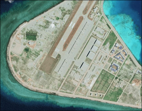
Maritime Operations and Berthing
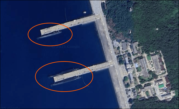
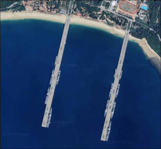
Recent imagery confirms:
- Multiple submarines docked at dedicated submarine piers, consistent with active maintenance or deployment cycles
- Surface vessels berthed at northern and primary piers, assessed as surface combatants or naval auxiliaries
- Pier layout and vessel separation indicate purpose-built military infrastructure, not dual-use (commercial) facilities
Concurrent submarine and surface vessel presence indicates active operational tempo and coordinated mission support.
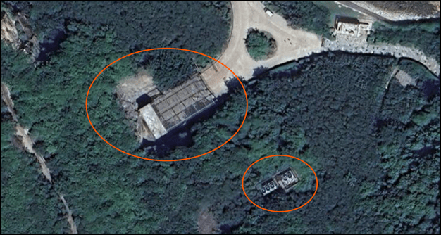
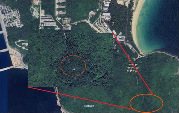
Subsurface and Hardened Infrastructure
Imagery analysis identifies multiple indicators consistent with underground facilities, including:
- Suspected subsurface access or support portals embedded in terrain
- Ventilation structures indicative of underground airflow management
- Road configurations suitable for service vehicles rather than civilian use
- Vegetation concealment and standoff from cantonment areas
These features align with known PLA practices for submarine survivability, protected maintenance, and ISR mitigation, and are assessed to support the underground submarine complex associated with Greater Yulin.
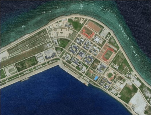
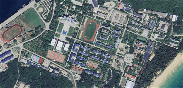
Personnel, Cantonment, and training Infrastructure
Integrated imagery shows a large, permanent personnel support complex including:
- Barracks and housing clusters
- Administrative and headquarters buildings likely to support C2
- Multiple training facilities, including running tracks, athletic fields, and courts
- Deliberate functional separation between personnel zones and waterfront operations
The scale and permanence of these facilities support assessment of continuous manning and high readiness.
Logistics, Sustainment, and Internal Mobility
The base is assessed as highly likely to include warehousing and support buildings for logistics and services, an internal road network optimized for controlled movement, and vehicle access patterns supporting movement between cantonment, logistics, subsurface, and pier areas. These elements allow for sustained operations without reliance on immediate external resupply.
Force Protection and Site Design
The overall site layout indicates a layered force protection approach:
- Facilities are embedded in dense vegetation and complex terrain
- Limited access points and internal zoning
- Spatial dispersion to reduce single-point personnel or mission vulnerability
- Proximity to defensive coastal geography and controlled maritime approach
Critical Nodes and System Dependencies (Training Assessment)
Key dependencies within the target system include:
- Submarine piers and support infrastructure
- Suspected subsurface access and ventilation nodes
- Personnel cantonment and training areas (establishes readiness)
- Internal road and service networks linking all subsystems
Disruption or degradation of these elements is likely to reduce sortie generation, sustainment capacity, and/or readiness over time.
Indicators and Warnings
Established baseline and surge indicators include:
- Increased submarine or surface vessel counts
- Heightened activity near subsurface access points
- Increased vehicle density along internal roadways
- Expanded use of training facilities or personnel movement
- Construction or modification near suspected underground nodes
Overall Assessment
Longpo Naval Base functions as a core operational hub for PLAN submarine and surface forces in the South China Sea. Integrated commercial imagery shows the base is actively supporting maritime operations, personnel readiness, and survivability through hardened infrastructure. The system is optimized for endurance, concealment, and rapid deployment, making it a strategically significant naval installation within China’s near-peer force posture.
Analytic Confidence: Moderate to High. External layout, functional zoning, and operational activity are well supported by commercial imagery; internal subsurface capacity and specific mission details remain less certain without additional corroboration.
Annexes
Annex I: Enemy Course of Action (COA) Table
| COA # | Assessed PLAN COA | Indicators | Implications for Target System |
| COA 1 | Maintain steady-state operations | Stable pier usage; routine training; normal personnel movement | Sustains baseline readiness |
| COA 2 | Surge naval operations | Increased vessel counts; expanded pier use; elevated traffic | Higher operational tempo |
| COA 3 | Disperse and conceal assets | Shortened pier dwell time; subsurface access activity | Improved survivability |
| COA 4 | Increase force protection | Activity at AA/SAM sites; access restrictions | Reduced ISR effectiveness |
| COA 5 | Shift C2 or sustainment | Changed logistics routes; admin redistribution | Increased redundancy |
| COA 6 | Conduct signaling operations | Visible deployments; state media coverage | Deterrence and messaging |
COA Assessment
PLAN activity is likely to remain at COA 1 absent regional escalation. COAs 2-4 are increasingly likely during elevated tensions, consistent with base design emphasizing survivability and sustained operations
Analytic Confidence: Moderate
Annex II: Node and Dependency Table
| Node ID | Node | Function | Indicators | Criticality |
| N1 | Submarine piers | Submarine berthing and sustainment | Submarines docked; pier utilization | High |
| N2 | Surface Vessel Piers (North) | Surface fleet berthing and support | Surface vessels present | High |
| N3 | Primary Surface Berth | Large vessel sustainment or staging | Large hull vessel docked | Med-High |
| N4 | Cantonment (Barracks/Housing) | Personnel sustainment | Dense residential blocks | Med-High |
| N5 | Admin/Command facilities | Base C2 and coordination | HQ buildings; road access | High |
| N6 | Training Facilities | Force readiness | Tracks; athletic fields | Medium |
| N7 | Logistics/Support Area | Stores, maintenance, services | Warehousing; service roads | High |
| N8 | Internal Road Network | Internal movement and control | Wide roads; limited access points | Med-High |
| N9 | Suspected Subsurface Access | Underground facility access/support | Hardened terrain-cut structure | High |
| N10 | Suspected Ventilation Node | Subsurface airflow/support | Vent-like rooftop features | Med-High |
| N11 | Suspected AA/SAM Site | Local air defense | Dispersed clearings; emplacement layout | Med-High |
Dependency Summary (Condensed)
- Maritime access: Required for operational throughput at N1-N3
- Personnel sustainment: Dependent on N4, N6, N7
- Internal mobility: Enabled by N8 linking all nodes
- Survivability: Supported by N9-N11 through concealment and defense
Annex III: Priority Intelligence Requirements (PIRs)
| PIR # | PIR | Tied Nodes | Why it Matters? |
| PIR 1 | What submarine and surface vessel types and quantities are present, and what are the rotation patterns over time? | N1, N2, N3 | Establish baseline v. surge posture, infer operational tempo |
| PIR 2 | What indicators confirm active use of subsurface infrastructure (access, maintenance, or storage), and how frequently is it used? | N9, N10 | Determines survivability and protected sustainment capacity |
| PIR 3 | Where are the primary logistics sustainment points (warehousing, maintenance, fuel transfer areas), and what activity indicates surge resupply? | N7, N8 | Identifies sustainment capacity and constraints |
| PIR 4 | What is the functional hierarchy of the command and administrative area, and what redundancy exists across Greater Yulin nodes? | N5 | Clarifies C2 resilience and operational coordination |
| PIR 5 | What force protection posture is observable, including air defense presence, and what changes indicate increased readiness? | N8, N11 | Supports I&W and resilience assessment |
| PIR 6 | What linkages exist between cantonment/training areas and operational nodes, and do patterns indicate surge manning? | N4, N6, N8 | Validates readiness cycles and manpower availability |